


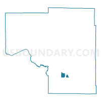
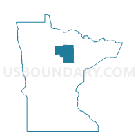
Grand Rapids P-4, Itasca County, Minnesota
About
Outline

Summary
| Unique Area Identifier | 602633 |
| Name | Grand Rapids P-4 |
| County | Itasca County |
| State | Minnesota |
| Area (square miles) | 7.71 |
| Land Area (square miles) | 6.65 |
| Water Area (square miles) | 1.06 |
| % of Land Area | 86.22 |
| % of Water Area | 13.78 |
| Latitude of the Internal Point | 47.20365680 |
| Longtitude of the Internal Point | -93.54538220 |
Maps

Graphs
Select a template below for downloading or customizing gragh for Grand Rapids P-4, Itasca County, Minnesota


Neighbors
Neighoring Voting District (by Name) Neighboring Voting District on the Map
- Cohasset Voting District, Itasca County, MN
- Coleraine West 2 Voting District, Itasca County, MN
- Grand Rapids P-1, Itasca County, MN
- Grand Rapids P-2, Itasca County, MN
- Grand Rapids P-5, Itasca County, MN
- Harris Twp. Voting District, Itasca County, MN
- LaPrairie P-6, Itasca County, MN
- Sugar Lake Prec., Itasca County, MN
Top 10 Neighboring County Subdivision (by Population) Neighboring County Subdivision on the Map
- Grand Rapids city, Itasca County, MN (10,869)
- Deer Lake UT, Itasca County, MN (3,495)
- Harris township, Itasca County, MN (3,253)
- Cohasset city, Itasca County, MN (2,698)
- Coleraine city, Itasca County, MN (1,970)
- La Prairie city, Itasca County, MN (665)
Top 10 Neighboring Place (by Population) Neighboring Place on the Map
- Grand Rapids city, MN (10,869)
- Cohasset city, MN (2,698)
- Coleraine city, MN (1,970)
- La Prairie city, MN (665)
Top 10 Neighboring Unified School District (by Population) Neighboring Unified School District on the Map
Top 10 Neighboring State Legislative District Lower Chamber (by Population) Neighboring State Legislative District Lower Chamber on the Map
Top 10 Neighboring State Legislative District Upper Chamber (by Population) Neighboring State Legislative District Upper Chamber on the Map
Top 10 Neighboring 111th Congressional District (by Population) Neighboring 111th Congressional District on the Map
Top 10 Neighboring Census Tract (by Population) Neighboring Census Tract on the Map
- Census Tract 4808.02, Itasca County, MN (6,046)
- Census Tract 4807, Itasca County, MN (5,066)
- Census Tract 4808.01, Itasca County, MN (2,412)